14 August 2008

Disused and dismantled

Yesterday was a day of disused and dismantled. I followed the Border south of Clones where it makes a mad loop back on itself. The result is a peninsula of the Republic sticking into the North. Its neck is only one hundred metres wide but from there it balloons out into an area twelve kilometres square. It was to even out just such twists that the Border commission was formed after partition. And no doubt they recommended the snipping of this particular headland. However, in the end, the commission’s suggestions were not acted upon.

A disused canel runs across this area. For a short while it constitutes the Border. I walk along it. I pass an abandoned warehouse with a large upper loading bay standing over the route. It will be waiting a long time for the next barge. What would it take to reflood this route? Or the others to east it could link to, such as the old Ulster Canal. The canal route I walked leads to Upper Lough Erne, and once you are there the west is your oyster.

I have walked a fair few dismantled railways toward their Border crossing points. In every case, so far, the Border has been a river along the area in question. So, I was checking to see if the bridge that once carried trains is still standing and now perhaps carrying foot-traffic. They never have been. The connection has always been broken. Either the girders have been exploded, as was the case with the Belcoo example from the July 27th entry, or its brickwork has been dismantled, leaving two stubby structures looking forlornly at each other across eight or ten metres of empty air. This dismantled railway bridge is the exception (44855, 19259).

I confess that strictly speaking this structure should not go on The Map of Connections. The growth on the southern side is too thick to easily walk through. But I cannot resist counting it as a connection. It is a rare exception I am making. I assure you this is not going to initiate slack standards. I cannot resist for one simple reason. It is beautiful.

12 June 2008

Points Without Lines


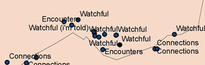
I will be publicly showing first drafts of The Map of Connections before the year is out. I am not certain what it will look like yet. A phase of graphical experimentation now begins. The above map is, as you can see, completely abstracted from the land. It shows all the connections I have mapped so far.

3 June 2008

Phyllis Pearsall

I have been reading about the life and work of Phyllis Pearsall. In the 1930s she noticed that London maps were completely inadequate. No surveying had been done in over ten years. So, she started walking, covering all of London’s 23,000 streets in the course of one year. That is about 3000 miles. Her map became the London A-Z. At first no publishers wanted to publish her new map so she set up the Geographer’s Map Company to do it herself.

By now the A-Z has become an exemplar of 20th century information design. One touch I particularly admire is marking house numbers on three points along each street, beginning, middle and end. There would not be enough space to include every house number but three is sufficient to describe the numerical trend of each row. As far as I know Pearsall invented this. Yet Pearsall never saw herself as a designer, but as an artist who drifted in cartography because bad maps were always getting her lost on the way to parties.

Pearsall’s get-up-and-go, grounded methodology, and plentiful eccentricities are enough to qualify her as a hero to my project. She is also an example of how the work of an independent cartographer can be absorbed into the mainstream if deemed useful (Pearsall herself gained an MBE). The A-Z is by now such a cornerstone of British Atlases that many people would probably be surprised to know it all began with an individual woman, walking and taking notes.

10 May 2008

Across the Blackwater


The Map of Connections is a map of unofficial Border crossings. Perhaps the most picturesque I have discovered so far are these substantial stepping stones crossing the Blackwater river. (Location: Ele 32m IH 71092 ITH 47266, Irish Grid) For a section the Blackwater is used as the Border between Tyrone and Monaghan, therefore the Border between northern and southern Ireland. There was no one around to ask about how and when these boulders were placed. It could have been twenty years ago, it was possibly two hundred.


The stepping stones are mere metres from Burn’s Bridge. Why did the locals go to the considerable effort of positioning the boulders with a bridge so near? As mentioned, it is possible the stones predate it. However, compare the worn stones of the arch to the left in the photograph and the smooth new stones of the right arch. I suspect this bridge was blown-up during the Troubles and only rebuilt recently. While this mode of connection was denied to them the locals may have taken things into their own hands. They built their own connection. Now I am happy to map it.

23 January 2008

At the peak of Holywell Hill


In Ireland the sound of desolation is the sound of wind blowing through the gaps in a pylon, sometimes accompanied by the uneven rhythm of a loose cable slapping against the metal infrastructure. You will be exposed. You will be cold.

Near Londonderry tracks make their way to the peak of Holywell hill from both sides of the Border. The Border goes right over the crest. Just in the Northern side is a holy well. A small pool is lined in stones. It is the most lonely and humble pit I have ever seen. Pipes, the leftovers from the engineering work nearby, have been left too close to it. The fence dips and two old stones have been placed to help people step over and visit the well. This is a connection for the Map of Connections. (Ele 264m IC 38535 ITH 17005, Irish Grid)

4 January 2008

My first map

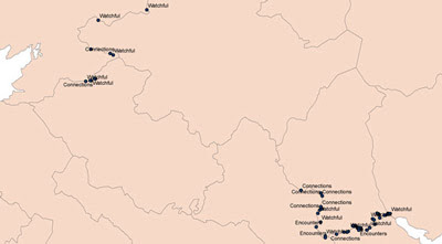
I use a GPS device to mark my discoveries along the Border. Back at Queen’s University I upload the data from the GPS, convert it with Grid InQuest, and display it cartographically with ArcGIS. Lorraine Barry is the technician in the GIS studio and I must thank her for answering all my damn-fool questions. I have never studied geography and when I decided to re-map the Border I did not even know what the Irish Grid was. As a beginner with the hardware and the software my outputs are basic but I am getting better.


On this scale many of points are lost but my first map does give an idea of how much of the Border I have travelled so far. I have a ways to go yet, I realise. The three types of marking refer to the different maps I am producing. Finished maps will no longer feature the border or county boundaries.

10 October 2007

Tim Robinson

One inspiration for my project is the West’s Tim Robinson. His maps of Connemara, the Burren and the Aran Islands are ultimately quiet traditional, based very closely on the Ordnance Survey, however they possess a fresh and beguiling human power. His Aran Mór map for example puts a name on virtually every crag and curve on its knobbly south face. These imply the kind of intense detail the islanders have come to known their island and suggest centuries of narrative. They speak of a landscape that is heartfelt by its human element. Loved or perhaps feared, but always known. You would not find these names on any other map. Robinson walks every mile of where he maps, tracing over the Ordnance Survey with updates, new information, and interests previously deemed unimportant by mapmakers. My interests are different but, like him, I will have to see everything with my own eyes. I wrote to him (my first fan letter) and in his reply Robinson advised me; “to do all that's necessary to preserve personal contact with the terrain on the one hand and the sheet of paper on the other.”