21 December 2008

Freedom of Information Act

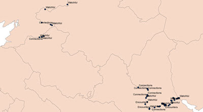
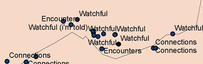
Image: Donovan Wylie. Tower Golf 40, south Armagh, west view. Wylie is represented by Magnum. www.magnumphotos.com

I went to the Ministry of Defence and requested the exact locations of British Military structures along the Border in the last thirty years. These will be just one of the defensive features marked on the Map of Watchful Architecture. I put in my request under the Freedom of Information Act. This was an act of parliament that introduced a public ‘right to know’ in relation to public bodies. It was a Labour Party commitment in 1997’s general election and came into force in 2005. Their manifesto said: "We are pledged to a Freedom of Information Act, leading to more open government."

Under the terms of the Act I had to be given the information within 20 days. I was.

The reply letter, that came with the spreadsheet of grid locations, was very politely worded. I was thanked for my request, they were “pleased to enclose” the information, and I was told how to complain if I am dissatisfied. It feels very New Labour all right. Searching around online I see that a criticism of the Act is that its range of exemptions is uncommonly wide, compared with other democracies, and there is a ministerial veto that can undermine the Act any time.

However, I’m not going to be too critical now. The existence of a one-stop Act for all your information requests is a very useful facility. Even if your requested is refused you will know why. That at least means you will be in direct debate with the public body and not just in a Kafkaesque process of being sent on to some other office and never getting anywhere. The Freedom of Information Act is democracy at work.

Next: I want to find out where the Republic of Ireland’s police force perform checks for illegal immigration from the UK. I know it happens on the motorway between Belfast and Dublin. Often when I take a bus south we are pulled over and all the passengers checked. But does it happen on other Border roads? And if so, which?

25 November 2008

The Last Watchtower not in Northern Ireland

I am charting the former locations of military checkpoints along the Border for The Map of Watchful Architecture. I went on to the Ministry of Defence website to seek the co-coordinates of these facilities. I used the Freedom of Information Act to request the information. I also asked for the former locations of military watchtowers, several were built on hilltops during the last deployment. Watchtowers that were reasonably close to the Border will also go on the map. There was a concentration of them in South Armagh but over the last few years all these towers have been dismantled.


While on the MOD website I discovered the demolition of one watchtower that did not make it into Northern Irish newspapers, a tower in England that was used for training soldiers soon to be deployed here. These English towers were put up in the 1970s. They simulated the conditions soldiers went on to experience. The final training tower was pulled down at Stanta Training Area in Norfolk on 6 February 2008.

A retired Lieutenant Colonel, who served with the first resident battalion in Londonderry in 1970 was there and was quoted:

These towers were built to simulate the conditions that soldiers met in the Northern Ireland campaign and enabled the soldier to received the training they needed. It was a very restrictive and confined space with up to 20 soldiers in each of the towers. Their key responsibility was observation but there were risks as well as you never knew when a sniper attack might come. This is a very important full stop at the end of a very long and significant campaign for the British military in Northern Ireland.

27 October 2008

From the Comments Book

The exhibition of the Map of Connections 2.0 and the Map of Encounters 1.0 is now over. A few days ago I went in and painted over the maps with a few coats of white emulsion. Thank you to everyone who visited.

Below, some remarks from the comments book followed by my replies:

“Makes you think different about Ireland and Northern Ireland,” Christopher.
“Some very interesting observations with attractive patterns emerging,” Helen.
“[ … ] place names on the photos would have been informative. Desmond.
“[ … ] Love to hear more about ‘unfriendly’ encounters and where the border gets lost,” Dan.
“Nice work, would love an excuse to explore Ireland this way, [ … ]” Miriam.
“Super duper,” Laura.

Yes, Miriam, I suggest you find that excuse. I suppose it is a part and privilege of artistic practice to go to places people normally do not. Nobody really visits the Border and that might be reason enough to go. Moreover, sections go through memorable country. The bogland north of Lough Derg and around Cuilcagh Mountain had a particular desolate beauty.


Dan, you raise a good point. I did include the vandalism of my car on The Map of Encounters but that is the only negative featured. (The stone pinned to the image, by the way, is the actual stone thrown. Not a stand in stone.) I went on my walks in a generally positive frame of mind and I suspect I was more alive to friendly, or natural, encounters. If I was not in a positive state of mind I probably would have gone home. I attempted to travel wide-eyed, as if seeing everything for the first time. This maybe preserved in the innocent atmosphere of the Map of Encounters. I feel both The Map of Encounters and The Map of Connections are attempts at a progressive, inclusive, and some how optimistic, cartography.

As for the Border getting lost, I am not sure it does. Although I certain got lost from it a few times. Several times I realised that, after half an hour, I was following the wrong hedgerow or ditch.

Desmond, your suggestion of adding place names to Map of Connections is something I am considering. Not to the photographs but perhaps to the map itself. I do want people to be able to engage with the map rapidly and not just find it puzzling. I like it that Helen found “attractive patterns emerging” but if that is the only level the work reached viewers then I may need to add traditional and ready-readable cartographical signs.

Thank you to everyone who commented.

11 October 2008

Belfast Exhibition

If you’re in Belfast in the next couple of weeks you can see, painted on the walls of PS squared, two of my maps. We had an opening night on Thursday and I hope everybody had a good time. Instead of fancy finger food I prepared samples of my typical Border trekking provisions: mackerel sandwiches, cheap bourbon creams, and bananas. “There’s great energy in a banana,” an Armagh farmer said to me, while handing me a banana. The above photograph was taken from out on the street during the opening.

I painted the maps directly on the walls of the space. Please click through for a closer look. The Map of Connections 2.0:


The Map of Encounters 1.0:


Thank you to Peter, the curator of the space, for giving PS squared over to my work and for all his advice and encouragement.

PS squared, 18 Donegall Street, Belfast. Opening hours: Tuesday to Saturday, 1 – 5pm. 14 – 16 October, 1 – 9pm. 18 October, 10am – 6pm.

29 September 2008

Drawing Encounters

I will be showing The Map of Connections 2.0 and The Map of Encounters 1.0 in PS squared, Donegall Street, Belfast. The show opens on the 9th of October. I will be going in four days in advance to paint these versions of the maps on opposite walls of the gallery space. The Map of Connections is a strict diagram already laid-out and ready to be projected. The Map of Encounters is still in development and will probably continue to be so until just before the show opens. It has plenty of potential content, photographs, notes, my equipment, and the occasional souvenir. Peter, the curator of the space, is encouraging me to go in and let the creation of the map flow in a loose and instinctual way. That is not easy for me, loose is not my style, but I can see it may be a beneficial process.

In the last few days I have been producing images for The Map of Encounters. These are two examples. The farmer’s land abutted the most southern point of Northern Ireland. He pointed it out to me. Further west I was excited to see the buzzard, south of Slieve Beagh, as they are uncommon in Ireland.

14 August 2008

Disused and dismantled

Yesterday was a day of disused and dismantled. I followed the Border south of Clones where it makes a mad loop back on itself. The result is a peninsula of the Republic sticking into the North. Its neck is only one hundred metres wide but from there it balloons out into an area twelve kilometres square. It was to even out just such twists that the Border commission was formed after partition. And no doubt they recommended the snipping of this particular headland. However, in the end, the commission’s suggestions were not acted upon.

A disused canel runs across this area. For a short while it constitutes the Border. I walk along it. I pass an abandoned warehouse with a large upper loading bay standing over the route. It will be waiting a long time for the next barge. What would it take to reflood this route? Or the others to east it could link to, such as the old Ulster Canal. The canal route I walked leads to Upper Lough Erne, and once you are there the west is your oyster.

I have walked a fair few dismantled railways toward their Border crossing points. In every case, so far, the Border has been a river along the area in question. So, I was checking to see if the bridge that once carried trains is still standing and now perhaps carrying foot-traffic. They never have been. The connection has always been broken. Either the girders have been exploded, as was the case with the Belcoo example from the July 27th entry, or its brickwork has been dismantled, leaving two stubby structures looking forlornly at each other across eight or ten metres of empty air. This dismantled railway bridge is the exception (44855, 19259).

I confess that strictly speaking this structure should not go on The Map of Connections. The growth on the southern side is too thick to easily walk through. But I cannot resist counting it as a connection. It is a rare exception I am making. I assure you this is not going to initiate slack standards. I cannot resist for one simple reason. It is beautiful.

12 June 2008

Points Without Lines


I will be publicly showing first drafts of The Map of Connections before the year is out. I am not certain what it will look like yet. A phase of graphical experimentation now begins. The above map is, as you can see, completely abstracted from the land. It shows all the connections I have mapped so far.

3 June 2008

Phyllis Pearsall

I have been reading about the life and work of Phyllis Pearsall. In the 1930s she noticed that London maps were completely inadequate. No surveying had been done in over ten years. So, she started walking, covering all of London’s 23,000 streets in the course of one year. That is about 3000 miles. Her map became the London A-Z. At first no publishers wanted to publish her new map so she set up the Geographer’s Map Company to do it herself.

By now the A-Z has become an exemplar of 20th century information design. One touch I particularly admire is marking house numbers on three points along each street, beginning, middle and end. There would not be enough space to include every house number but three is sufficient to describe the numerical trend of each row. As far as I know Pearsall invented this. Yet Pearsall never saw herself as a designer, but as an artist who drifted in cartography because bad maps were always getting her lost on the way to parties.

Pearsall’s get-up-and-go, grounded methodology, and plentiful eccentricities are enough to qualify her as a hero to my project. She is also an example of how the work of an independent cartographer can be absorbed into the mainstream if deemed useful (Pearsall herself gained an MBE). The A-Z is by now such a cornerstone of British Atlases that many people would probably be surprised to know it all began with an individual woman, walking and taking notes.

10 May 2008

Across the Blackwater


The Map of Connections is a map of unofficial Border crossings. Perhaps the most picturesque I have discovered so far are these substantial stepping stones crossing the Blackwater river. (Location: Ele 32m IH 71092 ITH 47266, Irish Grid) For a section the Blackwater is used as the Border between Tyrone and Monaghan, therefore the Border between northern and southern Ireland. There was no one around to ask about how and when these boulders were placed. It could have been twenty years ago, it was possibly two hundred.


The stepping stones are mere metres from Burn’s Bridge. Why did the locals go to the considerable effort of positioning the boulders with a bridge so near? As mentioned, it is possible the stones predate it. However, compare the worn stones of the arch to the left in the photograph and the smooth new stones of the right arch. I suspect this bridge was blown-up during the Troubles and only rebuilt recently. While this mode of connection was denied to them the locals may have taken things into their own hands. They built their own connection. Now I am happy to map it.

23 January 2008

At the peak of Holywell Hill


In Ireland the sound of desolation is the sound of wind blowing through the gaps in a pylon, sometimes accompanied by the uneven rhythm of a loose cable slapping against the metal infrastructure. You will be exposed. You will be cold.

Near Londonderry tracks make their way to the peak of Holywell hill from both sides of the Border. The Border goes right over the crest. Just in the Northern side is a holy well. A small pool is lined in stones. It is the most lonely and humble pit I have ever seen. Pipes, the leftovers from the engineering work nearby, have been left too close to it. The fence dips and two old stones have been placed to help people step over and visit the well. This is a connection for the Map of Connections. (Ele 264m IC 38535 ITH 17005, Irish Grid)

4 January 2008

My first map

I use a GPS device to mark my discoveries along the Border. Back at Queen’s University I upload the data from the GPS, convert it with Grid InQuest, and display it cartographically with ArcGIS. Lorraine Barry is the technician in the GIS studio and I must thank her for answering all my damn-fool questions. I have never studied geography and when I decided to re-map the Border I did not even know what the Irish Grid was. As a beginner with the hardware and the software my outputs are basic but I am getting better.


On this scale many of points are lost but my first map does give an idea of how much of the Border I have travelled so far. I have a ways to go yet, I realise. The three types of marking refer to the different maps I am producing. Finished maps will no longer feature the border or county boundaries.